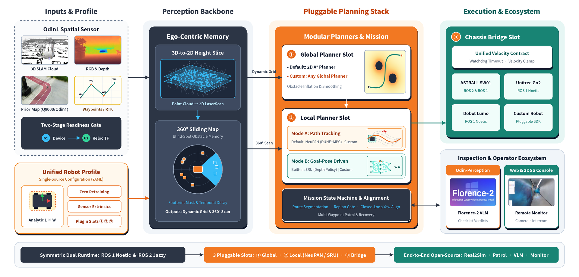
Built on the Odin1 (Odin's Eye) spatial memory module, ONS2 is an open-source, pluggable
navigation stack for industrial inspection—covering mapping, localization, planning, and execution, with live
3DGS monitoring dashboard.
Figure 1: ONS2 system architecture—unified robot profile, ego-centric perception,
pluggable planners, and execution ecosystem.
Upgrades that take the Odin Navigation Stack beyond ONS1.
01Dramatically faster planning
Plans substantially faster even on low-compute platforms, with smoother execution and nimbler obstacle
avoidance.
02Upgraded VLM, bring your own model
Connect a more capable vision-language model to your own workstation for richer scene understanding.
03Built for industrial inspection
Extensive optimizations tuned to real industrial inspection scenarios and long patrol routes.
04End-to-end, fully open source
A complete inspection workflow — simulation to real robots, algorithms to the monitoring platform.
See the Real2Sim tutorial.
05Plugin architecture
The stack is built around a plugin-based design, making it straightforward to integrate custom
planners.
More on the way
Further capabilities will land in upcoming releases.
Odin1 On-Robot
Working with Odin1
Q9000 (.lx) or Odin1 (.olx) captures the site; MindCloud exports three branches—navigation
maps, a live 3DGS dashboard, and Isaac Sim scenes—for ONS2 navigation, monitoring, and validation.
Figure 2: end-to-end workflow from site capture to ONS2 deployment.
This project showcases multiple demo pipelines built on Odin1. Each demo can be used
independently or combined as an integrated stack.
01SLAM
Build 3D maps for fast, persistent relocalization, providing positioning anchors for navigation.
It may take some time to load the 3D model.
02Navigation
Long-range navigation through complex skybridges connecting multiple buildings: one complete round trip of about 640 m, with ONS 2 maintaining precise localization and stable online navigation, free of localization drift or map misalignment.
03Real2Sim Navigation
Replicate real-world sites in Isaac Sim from Q9000 or Odin1 scans, import robot models (e.g., URDF), and run
navigation and manipulation tasks.
04Navigation in 3DGS Reconstructed Scenes
Built from Q9000 scanned 3DGS maps, the ONS 2 dashboard also runs in photorealistic
reconstructed scenes: here a Go2 quadruped descends an outdoor staircase in simulation, with the
viewpoint free to move.
3DGS scene with Go2 robot
More Exciting Features in Development
ONS2 keeps growing. Beyond this release, we are actively developing experimental modules—including
multi-floor navigation and human-aware motion planning. Stay tuned for updates!